Thursday, October 18, 2007

Sayonara

Well fellas.

I have to say so long. I hate it, but it's true. Took a tumble that put me down for a good while. I hope to be back next time around, but it depends on progress in physical therapy. I had lots of fun while it lasted--the dream class for sure. Just the right amount of not too much snarkiness, and plenty of levity. Good luck with the program, and keep in touch. I sure can use the distraction about now. I'll check in now and again to witness the awesome cartography you're sure to crank out.

Later, taters.

Wednesday, October 3, 2007

Oct. 3, 2007


Started a big map project of western NC, starting with Lidor raster data of elevation and hillshades, and adding cities, waterbodies, and points of interest, etc. I'm still having trouble with file management, and wondering if I'll ever understand computers well enough to be good at this. Anyway, I'm waiting for files to download, so I thought I'd get started on tonights blog. I took the exam before class (makeup) and feel I did pretty well. Now if I could only be so confident about my data management! And Pete just told me how to export map data and I completely spaced out on how to do it. But it's 9:30 and I'm tired of this mess, so I'm just going to upload my map, if possible, and be done with it. I say if possible, because the last time I tried to upload a raster-based image, it didn't work. But that was in Arcview. All the little dots are a city file that I haven't clipped to my region. But clips can't be performed on raster data, so I have to merge my county boundaries to create a layer file that I can perform edits on and clip layers to. That's where the whole export map data info Pete just gave me would come in handy. There's some way I can select attributes I want to keep (cities in my region) and export only those cities and automatically exclude the others. There's always next week, but I'm feeling discouraged, and wonder if it's all worth the effort. And work takes alot more out of me than I thought it would. I LIKE the work, but it certainly makes coming to class more difficult. I just wish I weren't such a computer dunce.

Wednesday, September 19, 2007

Killer Exam

I can't believe how hard Pete made the test tonight! Nothing like he was last semester! He asked questions about every little thing and it took forever to finish. He made up for it afterwards by sharing files for using google earth in ArcMap, so we could download shapefiles and connect with google earth to have the shapes and the aerial in one data frame. Pretty awesome. He let us play around with that a little bit and I flew all over the country on google earth--wisconsin, grand canyon, smokys, atlanta. It was pretty amazing. He also shared a short video about RSS feeds and how to set up an account on google reader--very entertaining. Alot more entertaining than the exam, for sure!

Missed having Edward in class tonight. We could have commiserated over the exam! If you read this, watch out Edward!

Wednesday, September 12, 2007

Class 4


Downloaded celltower info and played around in xcel to reformat data to make this nifty map. These are all the cell towers in North Carolina, at least the ones that meet criteria for the list we downloaded from the fcc website. I made some math mistakes in excel and my cell tower points all ended up in a diagonal line. I tried loading the file again, and they showed up as a big black "L." Pete helped me trouble shoot my source data and found an error in my excel formula. Frustrating, but I'm glad the map finally worked out. Then Edward helped me do a definition query to isolate NC counties from a US map, after he fastidiously removed the lint and cat hair from his sweater. He accumulated quite an impressive pile.


Josh really likes the sunshine layer we downloaded last week, and I wouldn't mind another look at that myself.


Pete did a power point on Earth-Map relations, and reminded us we have an exam next week. I'm really tired and ready to go home. Music night at our house tonight, so I'm not sure what I'll find. I'm hoping to find an adult beverage or two!

Wednesday, September 5, 2007

Class 3

Tonight I slogged through the ESRI 3D tutorial for draping images to display in 3D, and crashed a couple times trying to save my "scene." So, unfortunately, I don't have any pretty pictures to show you--yet. I'm presently downloading some data for Buncombe county that may evolve into a map. It was pretty cool, though, manipulating the 3D image of Death Valley. But now it's taking forever to download the county data, unzip the files, and add layers to Arcscene. I wish we'd learned about this in intro class last semester. And it seems as though my computer is taking the longest of all to download and recover from crashes, which only adds to the complex I'm getting from the Y-chromosomes in the room. I'm in the company of some pretty savy fellows. But we had a nice look at Edward's tiny cam photos, and some google streets from San Francisco while we waited.

Anyway, I finally got the elevation and streets layers added, but I'm not able to export and save the image in Arcscene (.sxd) as a .jpg and upload into the blog, so you'll have to take my word about how cool it looks. The blog seems so inadequate without some graphics and I feel compelled to say something clever and entertaining, but alas, it's late, my brain is mush, and my wit is not on command.

More next week.

Wednesday, August 29, 2007

Winging the lab
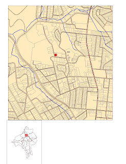

Class 2, catching up on the lecture and all kinds of freedom for lab. I downloaded layers from the City of Asheville file and some from the buncombe county website. Some simple things took me a long time to accomplish because I couldn't remember exactly how to insert symbols and create new layers--I'd just been adding layers so far. Last semester was a loooong time ago. Anyway, I was trying to do a proximity map, similar to the landslides project last week, but got too caught up to finish. Here's what I have so far.

For some reason, I had a hard time figuring out where the parcels were located.

Josh was in class tonight--I was wondering if he was still in the class after missing last week. Nice to see him.

So, another long day, and I'm ready to head home. Music night at our house tonight, so I'm looking forward to a nice cold adult beverage.

See you next week. Same map time, same map channel.

Wednesday, August 22, 2007

I'm Baaaack
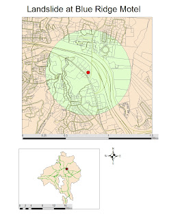

First day of GIS fun this semester and we've already made a map. Man, it was hard remembering how to DO some of this stuff. But I AM remembering how stupid this can make me feel. I really have such little experience with computers--just saving files and getting them into my map can be confusing. Am also remembering how much I like Pete as an instructor--very patient and helpful.

I didn't quite have time to add the legend because the insert function automatically uses the titles in the table of contents. The descrptive titles for the symbols would have been file names without being changed in the table of contents. Also, the scale needs tweaking a little bit, and if Id had more time, I would haave played around with the colors a little bit.

Only 5 of us in here, and only one new classmate. Was nice seeing familiar faces--especially my friend Edward. I'll have a tendency to rely on him for help--he's such a computer whiz, and I'm more like a computer whatsit. Hope he doesn't get too annoyed.

Also, I need to remember my flash drive next week.

I'm a little worried about all I have going on right now, too, and hope Ican devote the time I want to the class. I'm certainly in a time of transition. I think having GIS to focus on will be helpful.

Wednesday, May 2, 2007


So, here's the final GIS project for this semester's intro class. I'm glad I finally finished the map document, but I still have to finish the written report.
I'm going to miss seeing Edward every Wednesday night. I'm hoping we can get together for beverages once in a while. I was also glad to hear that Pete will probably teach the next class in the certification series, and it will be offered this summer in the evenings. Not sure I'll be able to swing that with work, but if not, I'll certainly try again in the fall. I sure wish I'd had more time to play around with the graphics. If I weren't so slow.... and if my computer weren't so s....l....o.....w.! Anyway. It was a great experience. I look forward to the next class.

Wednesday, April 25, 2007

Project map


Well, here it is. I've added all the layers I need and clipped to the watershed. I even color-coded the land use and labeled them in my context menu. I still haven't done any calculations, nor have I started the report. This weekend is the wildflower pilgramage, so I don't know how much time I'll have to work on it then. Plus, I'm working Wednesday for Debbie because of her surgery, so I won't have time then. But I think I did Ok on the test tonight, so if I can't get the final project as finally projected as possible, I'll be Ok grade-wise. I can't believe we only have one more class left. I've learned a lot, but still feel there's so much more to learn! Hopefully I can take the next class in the series, even if it's offered during the day. And hopefully Pete will get hired full time and teach the next class. Good luck on your interview tomorrow, Pete.
Watch out for grenades launched from M-16's.

Wednesday, April 18, 2007

Final Project, phase one

Didn't have much patience tonight for some reason. I still feel so clumsy navigating my way around. I get caught up and then forget simple things and my brain turns to mush. So I've added necessary data layers and Edward helped me unzip the street file. Here's what I have so far.

Well, that's just indicative of how the night has gone. There was an error uploading my image. I don't know what's going on with me, but I just can't seem to remember how to perform the simplest functions. And now I've learned that we have a test next week and we also have to write a report on the whole project thing. Which adds to the frustration of not being able to work on any of this at home. I'm so freaking slow and I hate feeling so stupid. I don't know when I'm going to find time to do anything. Arrrgh.

Wednesday, April 4, 2007


Did better than I thought on the exam, and I got my queries quiz back. I also practiced some spiffy editing, as seen in the uploaded image. Except, I guess all I exported from the map was this little corner of the street grid I made. Maybe I should open the file back up and export the entire projection. Stand by.
Ok. There's the mildly interesting roads I drew with the
tiny little green parcels and such.
I was exhausted in class tonight, running on empty since my bowl of granola and a banana at noon. Pete to the rescue with some Domino's delivered to the classroom! Thanks for the Pizza, Pete. Whatta guy.
I still really wish I had Arc software to practice with. It's frustrating only using some of these tools and applications just a few times. It would be so much easier if I could use it more and become more comfortable and familiar with everything. Anyway. I'm determined not to be the last one left clumsily plucking away at the keyboard tonight, so I got started early. Tune in next week for the next updated GIS experience.

Wednesday, March 28, 2007


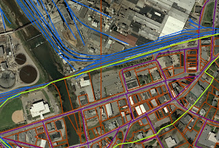
So here's my new shape file of downtown Canton. The bright green line is the boundary I drew that delineates "downtown" Canton. Never knew there WAS one, didja? The blue is railroads and the red are parcel boundaries. I tried to follow roads and existing boundaries as best I could, but the information we had to go on was a pencil line on a xerox copy of the aerial photo that some lady in the planning department drew for Pete. "Welcome to the real world," he says.
Feel like I did OK on the exam tonight, considering how much of a slacker I've been. It could have been a lot worse--seems I lucked out on some guesses I made, but I should keep my mouth shut until he grades them. I don't want to jinx myself!
Poor Edward lost all the arduous tracing he did for his outline. I was right next to him and witnessed the moment of panic when digital technology determined his destiny. He pulled through it pretty well, and I plan to check blogs more diligently in the next week.
We also talked about the next GIS course being offered at AB Tech this summer--on weekday mornings of all times. Hopefully by then I'll be working for Equinox, but a morning class would still be hard for me to pull off.

Wednesday, March 21, 2007

Catching up


Felt a little remiss for missing class last week, but I think I'll be Ok. Won't have the same kind of time free to study for this test like I did the last one, but I've learned all I can about editing in one night. Had a little chat with Edward about my beltsander blog and discussed some LP business with Pete. Oh yeah, I made this little Rapid City map thing, too, which as Edward pointed out, was decievingly quite arduous to complete. Found out there's some happenin laundro-mats in that SD town. Never know what kind of information you'll come out of a GIS class with!

Wednesday, March 7, 2007


Man! The computers tonight were S...L...O...W..... or, at least mine was. It was so slow, I had to drive the unit in the front of the class while Pete directed us through the steps, or else I'd have another nifty watershed map, too. And Edward gave me some kind of computer crasher complex and it turned out his flash was full. My oh my, whatta night. But here's my buncombe county land use map after it was appended, clipped, dissolved and buffered. All these tools from the toolbox and I'm feeling pretty handy. Speaking of tools, I felt girlscout-prepared when Pete inquired, "Does anybody have a screwdriver?" and I whipped out the mini-leatherman like it came out of ARC toolbox. Never thought I'd need a screwdriver for GIS class. Now I'm anxious to rummage around in that little red box and do a little experimenting--maybe a little modeling one of these days. I'm having visions of community mapping and habitat suitability and restoration design. Now THAT will be exciting. Not as exciting as the belt-sander I got for Valentine's Day, but that's a topic for another blog.

Wednesday, February 28, 2007

Feb. 28

Took the queries test tonight. Feel like I did OK, since we had a good review beforehand, but we'll see.

Pete seemed a little distracted tonight for some reason--a little more scattered and disheveled than usual? (I'm not the only one who noticed). Been up a while Pete?

Enjoyed a beautiful pink sunset behind Pisgah out the classroom window, though. Not to say I was looking out the window and not paying attention, but there was a little down time while everyone completed exercises and practiced queries.

Just checked out my blog and I have 8 posts. It's hard to believe we've had 8 weeks of class and it's already the end of February. Weird how time flies.

So the whole joins and relates concept with tables seems pretty straight-forward except for the few caveats that will probably solve themselves with time and familiarity. Only question I think I'll have once I get more into it is knowing which table to relate to which--as in, which direction to join or relate. And I'm sure that will be determined by how the data is being used, but I know the direction probably won't always be interchangeable. Like I said--caveats that will be resolved with experience.

By the way, Edward is a very sneaky photo pirate with his tiny camera.

Wednesday, February 21, 2007

Whew
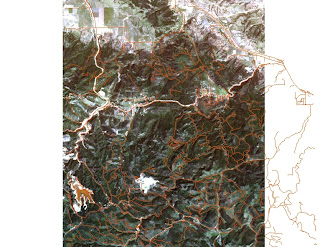

Especially tired tonight, but made it through the tutorial with my sturgis raster image matched nicely to the forest roads, see? And for your veiwing pleasure, I will add the images I couldn't get uploaded last week. I realize now I was in Edit Html mode instead of Compose so the images weren't projecting--learned all about projecting images tonight. I do want to become more familiar with the Datum formats and coordinate systems.

Here's my lovely NC counties map with the scale bar I made for my friend, Reed, who will plot on it the results from a woodrat habitat survey he did. Hope it gets published.

Hey Pete, if you see this, will you post the supplemental power point from class either on the AB Tech black board or on your GIS Blog where we can access it?

Everybody ready for the Query Quiz next week?
See ya then.

Thursday, February 15, 2007

so I'm happy

Didn't have time to post during class last night, so I'm catching up from home this morning. But why won't my map jpg's upload from my flashdrive? All I'm getting on the blog after upload is a bunch of text. Oh well.

Did pretty well on the exam, so I'm happy about that. Had plenty of chocolate cake with my SO after class, so I'm happy about that. The book exercises were really a drag. Seems like they didn't contribute to any real product--every map we created, we just erased to make a new map. Seems the previous chapter exercises all compiled into one big final map, which was a bit more rewarding than just going through the motions in chapter 6. Anyway, I did get the NC counties map I wanted, so I'm happy about that.

Wednesday, February 7, 2007

GIS feb 7


Here's the wonderful percent hispanic population map from the chapter 5 exercises! I actually finished this time! But I moved through the steps so quickly and mechanically, I'm not sure how much really sunk in. I'll have to spend some quality time with the text to sort it out, I suppose.
Test tonight was OK. I think I did pretty well--missed the shapefiles question (how many files), and was a little uncertain about what, exactly, the arrows were pointing to at the very end, but I still think I squeezed an A.
Thanks for the dumdums, Pete.
I added a link to Edward's blog (the "other" GIS blog), so check out his "moving pictures."

Wednesday, January 31, 2007


I just lost all the %$#%*! work I did in lab tonight. I only made it to pg158 in the tutorial--"classifying data." It's gone. I didn't save like I should have. Shit. The only thing I have to show is my snow routes map.

I can't believe I did that.

Comments for class (If you read this, Pete):

I liked having more time for lab last week. Our guest instructor gave us plenty of time to explore and familiarize ourselves with tools and such. Also, it gave us (me) time to fix mistakes or backtrack. It would be nice to limit lecture since we have access to powerpoints and it follows the text so closely. Otherwise, I feel Ok about my progress. Except for losing my file this time. And I would have liked a review for the test. I'll have to come in on my own time to make up for what I lost. Shit.

Wednesday, January 24, 2007

GIS class #3


That was pretty cool--finding where I live on the city map--adding layers and highlighting plots and such. But knowing how easily that information can be accessed is kind of scary. Now if I can only remember how to export images.

There we go.

The work in chapter nine is the kind of stuff I can get caught up in--colors and fonts and borders and patterns. Maybe deep down I'm really a graphic artist. For example, I think the schoolchildren photo we added to the Rapid City map is pretty lame. And it needs a border to balance with the other data fields. And I don't know whatever happened to my "Rapid City" label, but it's not on the map. Looks like I still need work on labeling so I'll go back to chapter 2 and review. Sure wish I could play around with this stuff at home.

Wednesday, January 17, 2007


I feel like I'm just so slow navigating through all this. I'm not too computer savy and it seems to take me forever to complete the lab assignments. Doesn't help this is a night class. I feel my brain is much by this time of day. Plus, I get caught up in playing arround with all the different options and ways to manipulate the image, which is good, I suppose, because I'm learning how to use the tools, but it also adds to the time it takes to follow steps in the book. I really wish I could work on this at home to familiarize myself more with tools and icons. And I've only just switched from PC to Mac about 6 months ago and now I'm trying to get used to the PC ms layout again. Is everyone else just zooming through the exercises?

Wednesday, January 10, 2007

First GIS class experience

I've finally been initiated into the world of weblogs. Imagine that. Not sure who I'm ready to admit that to.

I'm glad the lectures and powerpoints are available on line. And I'm glad the lecture material seems to follow the text pretty closely. But I wish I could play around with the GIS programs at home.